
In this chat, adventure athlete Jason Hardrath catches up with good friend and fellow sufferfest enthusiast, Nathan Longhurst. After teaming up on Journey to 100 and Journey to Infinity, Nathan has just completed his wildest projects yet: climbing and flying from New Zealand’s 100 Greatest Peaks, a feat that has only been completed by one other person. The mission landed Jason in publications such as Climbing Magazine and earned him the nickname of “The Para-Alpinist” by The Climbing Majority Podcast. Listen in as Jason and Nathan dig into the vision, the chaos, and what it takes to pull off a mission this big for Path.
What inspired you to take on the New Zealand 100 Greatest Peaks Challenge?
I first came to New Zealand in March and did some flying and a little run-and-fly speed record on one of the prominent 3,000-meter peaks. The trip was meant to be two weeks, but I ended up staying almost a month. The mountains just blew me away. It was late in the climbing season, so a lot of the glaciated peaks were in poor condition, and I didn’t get to climb the central high peaks. But even just seeing them from below, I knew I had to come back.
Back in the U.S. that summer, I started researching ideas. Initially, I thought about only doing the peaks over 3,000 meters. There are 26 of them, and some local climbers had done that pretty fast, in about a month. But when I found the 100 Peaks list, it totally changed things. It included most of the 3,000-meter peaks but also added tons of variety—peaks across both the North and South Islands, ranging in size, terrain, and style. At first, I thought, “That’s impossible to do in a summer.” But with the flying aspect, it started to seem maybe possible.
What was the elevation breakdown like? I imagine not all of the peaks were 3,000 meters.
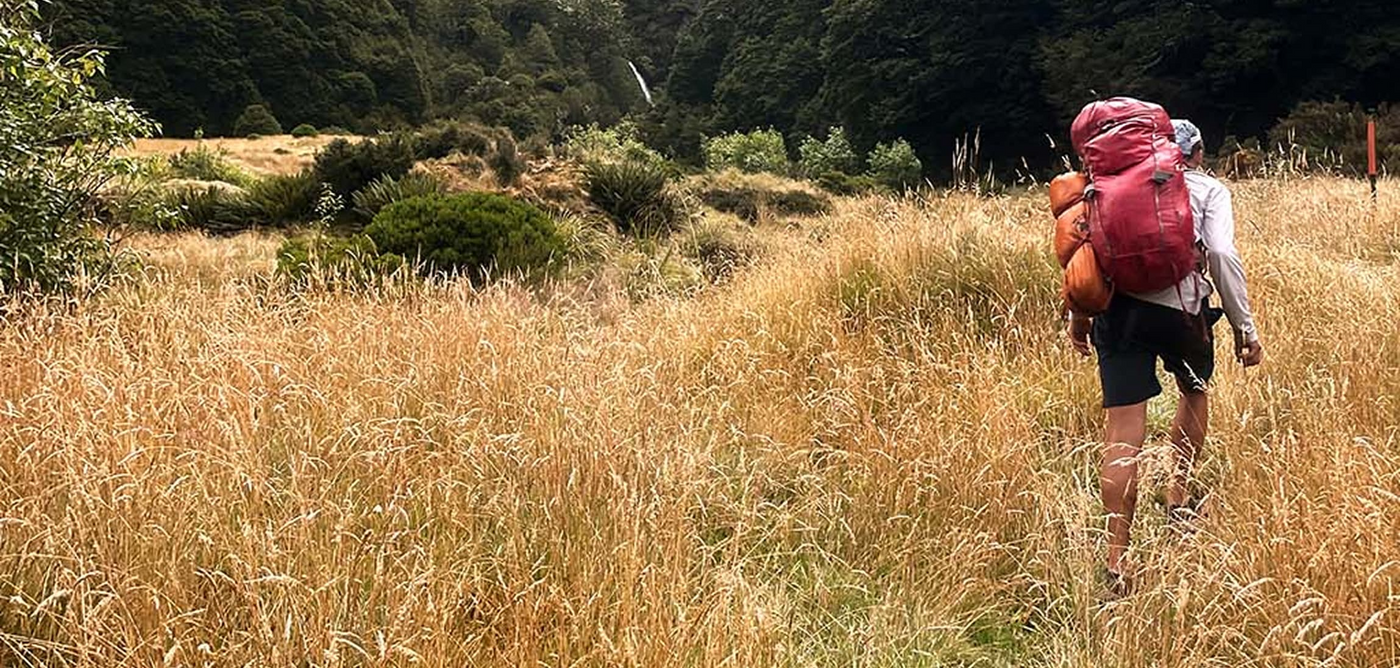
About 20 of them were 3,000-meter peaks. Most were between 2,000 and 3,000 meters, and then a handful were below 2,000. Some of the shorter ones actually have massive vertical relief because you climb them from sea level. Even though they're technically under 2,000 meters, they still felt like big mountains. There are almost no trails to most of these peaks. Lots of bush-bashing, endless boulder hopping up remote valleys, glacier travel, technical ridgelines. It’s not the kind of terrain you move quickly through on foot.

What did a typical day on the project look like?
It varied a ton. Some days were quick—just a few hours to run up a single peak and fly off. Others were big multi-day linkups that started at alpine huts on glaciers. On a single peak day, I’d usually start before sunrise to beat the afternoon winds, and make decisions and gear adjustment depending on the terrain, forecast, and gut feeling. If flying was on the table, I was always watching cloud development and feeling the wind as I climbed—trying to time it right to fly off safely before weather shut things down. It’s a humid, maritime climate here, kind of like parts of the Alps, so clouds build fast in the afternoons. It often became a race to beat the clouds to the summit. Flying into clouds is not only dangerous, it’s also illegal, so the pressure was real—run, climb, launch, land before it all socked in. If not, I’d hike down, which was just as slow and rugged as the way up. There were definitely days where I raced the weather to the summit and lost—those were long days.
How many of the peaks were you able to fly from?
Initially, I thought I might be able to fly from 25 or 30. In the end, I flew from over 60. I got really lucky with the weather. A local pilot I talked to said the jet stream had shifted this summer—it was hitting the Southern Alps more parallel to the crest instead of perpendicular, which meant less turbulence and more stable conditions. It gave us an unusually long stretch of calm weather.
How much time did flying save you?
A lot. These aren’t peaks with nice trails where you can jog down quickly. On foot, it could take eight or more hours round trip. But the descent alone might be four hours of gnarly terrain. In contrast, the flight is ten minutes. That’s not only saving time, but also a lot of wear on your legs. Plus, in a few cases, I was flying over terrain that would have been really dangerous or even impossible to solo—like big glaciated areas that I wouldn’t have felt safe moving through on foot.
But it also added a lot of mental stress. On days when flying wasn’t possible due to weather, it was almost a relief. I could relax more during the climb, not constantly evaluating every gust of wind or cloud formation. On flyable days, I had to stay fully switched on the entire time. It was a huge advantage, but added a whole new layer of complexity.

Have a favorite memory from the project?
That’s tough, but one that really stands out is Mount Tūtoko, down in the Darran Mountains near Milford Sound. It’s not the highest peak on the list—around 2,500 meters—but the relief is huge because it rises almost from sea level. It’s a big, glaciated, bulky mountain with steep faces on all sides.
I had perfect weather: totally clear and calm. I climbed a classic knife-edge alpine rock ridge, maybe Grade 15 on the Australian–New Zealand scale, which is mid-fifth class. The rock there is unusually solid for New Zealand alpine terrain, and the setting is just unreal. You’re next to these enormous cascading icefall glaciers, with ocean views from the summit, and big peaks in every direction.
The flight down was pure joy. Instead of going for max glide, I got to fly more dynamically—diving through terrain, following the line of the icefall, almost like a speed-flight descent. Super fun. I landed in the early afternoon, took a nap, and ate some meat. Pretty much a perfect day.
What were some of the challenges you encountered?
One of the biggest things was just the mental fatigue of being out in rugged, technical, exposed terrain day after day. Managing full-on technical flights from difficult, rough launch sites, often in less-than-ideal conditions (maybe a bit windy or thermic) was intense. And then, after the big day, I’d have to get back to the car and instead of collapsing like I wanted to, I’d be planning for the next day: organizing gear, charging all my electronics, buying food, driving to the next trailhead. It was a ton of cumulative mental stress. Physically, I was conditioned for it—I've been doing big days for a lot of years—but the constant mental load was definitely the bigger battle.
Tell us about your standard gear kit for a high alpine, glaciated peak day?
It varied a lot, but a typical day would include food, water, wing, harness, helmet, and my electronics setup: an inReach satellite beacon, COROS watch, GoPro, phone, and a couple headlamps. I’d also carry a few pairs of sunglasses and a small first aid kit with a tourniquet, pain meds, and tape.
Depending on conditions, I’d either wear La Sportiva ice boots with Petzl Lynx crampons or just trail runners and microspikes. I almost always had two ice tools—Petzl Gullys—super light but super capable. I’d also pack layers, like a Gore-Tex shell and my go-to Path Projects Wadi Sun Hoodie.

I saw that hoodie in a ton of your shots—you wore that thing a lot, huh?
Almost every day of the project. That thing was gold. The Wadi Sun Hoodie nailed it—super breathable, held up to constant abuse, and gave me the sun protection I needed without overheating. Guides and mountain athletes are always searching for the perfect sun hoody—durable but not too hot. This is it.
When you’re hiking up with your gear, how much extra weight are you carrying with the wing?
That varies massively depending on the type of wing. For this project, I used two different wings. One was the Dudek Run & Fly—a 16-meter single-skin wing that’s designed to be as light as possible while still being flyable. It’s super easy and safe, but kind of flies like a cardboard box—straight and down. That one weighs just one kilogram. The other was a Nova Bantam 12—more of a dynamic speedwing. It’s super fun to fly—barrel rolls and everything. That one weighs 1.6 kilograms.
Are you working on a video recapping the project?
We are—we’ve got a ton of GoPro footage from the trip. I filmed every day, and we’re planning on putting together a 30-40 minute film. It might take a couple of months, but I think it’s going to be really nice. It will be aimed at film festival season—I’ll put out updates on my socials and through Path as it releases.
After sharing over 100 summits together, Jason and Nathan have built a mountain-tested friendship that runs deep. With Nathan fresh off this wild 100-peak New Zealand mission, the two are already cooking up plans for a big climb-and-fly trip together in summer 2025. All they would tell us is they are calling it, “Chasing Midnight Sun” and it’s gonna be one for the books.
Follow Nathan on Instagram: @nathan358
Follow Jason on Instagram: @jasonhardrath


