
Just an hour drive from Los Angeles and Orange County, you can find Mount San Antonio, aka Mt Baldy. This is my favorite local trail to run and hike. The views are absolutely breath taking from the highest point of Los Angeles County, overlooking the San Gabriel Mountains and Angeles National Forest. The summit is at 10,064 feet / 3067 meters and can be reached via a few routes. We like the route with the most elevation gain, because, you know, there is nothing like 6k feet of gain on a 6.5 mile trail :)

My favorite route to Mt Baldy Summit
Bear Canyon Trail starts from Mt Baldy Village and goes up for about 6.5 miles before hitting the Summit. The ascent of this trail up Bear Canyon is more technical and advance, therefore much less crowded than other routes to the summit such as Manker Flats. From the Summit, I prefer to descent the Devils Backbone Trail, it's less steep on the downhills and more runnable.


You can can park at the Mount Baldy Visitor at 6778 Mt Baldy Rd, Mt Baldy, CA, 91759. There are 6 parking spots on the street side of the Visitor Center. There are also options to park at the Ranger Station. My friends and I like the beat the crowds and usually start at 5am. There is usually enough parking early in the morning, however it gets busier as it gets later. Don't park at the Church parking lot and watch the signs when parking along the street.
Starting Point of Bear Canyon Trail
Once you have parked, you can walk to the Mt Baldy Village Church parking lot. This connects to Bear Canyon Drive (blue line on image below), this is paved for a few minutes, then it turns into a dirt trail.

You follow this dirt trail until you come to a sign that guides you to Bear Flats (left) or Mt Baldy (right). You turn right and start making your way up the mountain, whenever in doubt, follow the Baldy Trail sign and keep heading up.

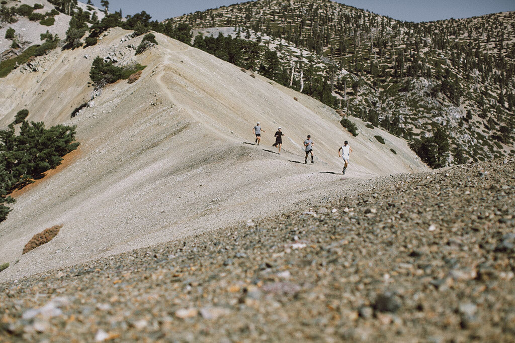
Mile 3 to 5 of this run / hike are the steepest and some sections are not very runnable. Mile 3 gains 1,280 ft, mile 4 gains 1,111 ft and mile 5 gains 1,098 feet. The trail is easy to follow with great views of the sunrise if you start early, often above the clouds.

On one of our trips to Mt Baldy, we brought along some friends to shoot photos for Path Projects. They don't run or hike much, and we all underestimated the difficulty of this route for them. Next time I'll let them know in advance it's a 17 mile run with 6k ft of gain. The good thing is, we all survived! :)

 As you get higher, you are going to see a more open ridge lines. There are spectacular views of the valley and the surrounding mountain peaks, such as Bighorn and Ontario Peaks.


David Villalobos, Scott Bailey (founder Path Projects) and me Floris Gierman. We all got the grey shirt memo.

From here you get to my favorite section of the trail, called ''The Narrows'' with steep drops on both sides.


Be careful here, especially during winter months when it can be snowy and icy up here. Snow spikes are a must during winter runs and hikes. This is at about 9k feet elevation.

After you pass The Narrows, the steepest climbs are done and you can cruise to the Mt Baldy Summit.


Devils Backbone Trail to Top of the Notch Restaurant
Typically it takes you several hours to get from the Bear Canyon Trail to the Summit of Mt Baldy. By the time you start descending, there are usually several other hikers on the trail. The Devils Backbone is mostly single track, so keep an eye out for hikers of all levels from beginners to advanced. Follow the trail for several miles to get to the restaurant.


Top of the Notch Restaurant
There is a nice restaurant located around 7800' elevation. They offer breakfast 8am to 11am, lunch 11am to 5pm and dinners at 7pm for tent cabin guests and other special engagements. They also have a bar with selection of craft beers, wines, hot chocolate, etc. Great views overlooking Southern California from the deck, the inside tables or the bar. To find out the latest schedule, check their website.


The drinks and food taste amazing after spending 8+ hours on the trail.
Getting back to the Mt Baldy Visitor Center
From the Top of the Notch restaurant, there is a comfortable downhill fire road for about 3 miles that takes you all the way to the bottom of the ski lifts. The fire road turns into a paved road, that intersects with the main Mt Baldy Road. You take this down for another 4 miles back to your car at Mt Baldy Village. This is a nice 350' to 500' per mile decent. If you still have legs left, you can run some fast downhill miles here :)
Wildlife at Mt Baldy
There is a lot of wildlife in the habitats of Mt Baldy's mountain regions, such as black bears, coyotes, mountain lions, raccoons, big horn sheep, mule deer, bobcats, gray foxes, California Mountain Kingsnake, Western Diamondback rattlesnake, Cooper's Hawk and much more.
Be aware that you may cross paths with local wildlife. Driving up to Mt Baldy village, I have encountered several deer in the middle of the road, so drive slowly. We have also seen several fresh bear tracks in the snow.

Black bear front and back track, likely moving at a slow gait. They can smell you from a very far distance. It likely passed by shortly before us.
Mt Baldy Run to the Top

This race started in 1966 and has been happening for 53 years. A 7+ mile trail run through the Angeles National Forest, from the entrance to the Ski Lifts parking lot, at 6,000', and finishing on the summit of Mt Baldy, at 10,064'. I have heard great stories about this race, you can find out more on their site.
FTK Fastest Known Times for Mt Baldy Summit
There have been some fast times going up Bear Canyon route to the summit. The ascent via this route has a Strava segment. In 2015 Chris Price set the FTK in 1 hour 31 minutes 2 seconds, much respect to how fast he ran it! You can read more on the Fastest Known Times site and on Chris's Strava and Flybys.
Final words
This post became much longer than anticipated, there is just so much to see in this mountain range. The Bear Canyon route starts around 4k feet elevation and gains 6k over 6 miles. Don't underestimate the difficulty of this route. Several sections are better to hike than run, to safe your energy for later parts of the day.
There are no water filling options, until you get to Top of The Notch Restaurant, after about 10.5 miles from your start. It's important to bring plenty of water, since you will be out there for a while.
Be aware that Mt Baldy has experienced snow early in the season and I've seen snow storms here as late as May. The temperatures cool down significantly the higher you climb. Before you plan to summit, check the weather forecast, to avoid unexpected weather. The Mountain Forecast website is a great site to bookmark.
If you have any questions about this trail, let me know in the comments. Have fun out there and be safe!


2 comments
When is this race. And were do I register
Hello there, I’m planning to hike Mt. Baldy, but not sure if I need to buy a bear spray? Any suggestions please. Thanks