
Many adventurous souls aspire to thru-hike the 2,193-mile Appalachian Trail (AT), which runs from Springer Mountain in Georgia to Mount Katahdin in Maine. Completed in 1937, it traverses 14 states with more than 500,000 feet of elevation gain and loss and hosts more than 2 million hikers per year, many thousands of whom are attempting the entire trail -- yet only about one in four succeed.
Though thru-hiking the AT has been discouraged by the Appalachian Trail Commission in 2020 and 2021 due to the Coronavirus pandemic, I was lucky enough to have some spare time between overseas tours in 2018 to give it a go myself, and it was one of the best decisions I have ever made.
Beginning on March 25, 2018, I headed north from Springer Mountain on a misty and drizzly day. Having run ultramarathons for over a year at that point and recently setting the FKT on a little-known trail on the Mediterranean island of Cyprus, I thought I had a good idea of what I was getting myself into but would soon be humbled by Mother Nature.

Fresh-faced and taking my first of 5,000,000 steps on the AT!
I had done months of research to ensure I had some of the best and lightest gear on my back as well as continued my trail running and strength training in order to prepare for the trip.

All my gear to start the trail, weighing in at about 12.5 pounds without food and water.
After a couple of weeks on the trail, my summation of the experience thus far was that it was colder and more difficult than I had imagined. Because of my limited timeframe between work commitments, I needed to finish the trail in 100 days - about twice as fast as the average thru-hiker. As such, I needed to start in March when the temperature in the Georgia and Tennessee mountains routinely drops below freezing at night while also covering about a marathon’s distance per day. By the time I reached Damascus, VA (mile 470) I was suffering from a crippling case of Iliotibial Band Syndrome (ITBS) and had endured multiple nights of shivering myself to sleep in addition to hellacious rainstorms. Despite this, my spirits were high and I pressed on.
 A snowy and sub-freezing day in April.
As I inched evermore north, the weather got warmer and my injuries subsided with proper attention and stretching. The miles came quickly, but not easily, and I got into a groove that propelled me through the mid-Atlantic states of Virginia, West Virginia, Maryland, and Pennsylvania (also known as “Rocksylvania” for the shoe-devouring boulders, slabs, and rubble that constitute the northern half of the state). I received rides, food, and places to stay - known as “Trail Magic” - from friendly “Trail Angels”, hiked for a time with a great group of people who called themselves the “Northbound Horde”, and made it to the halfway point more motivated than ever.
 The ATC Headquarters in Harpers Ferry, WV is the “spiritual” halfway point of the trail, although the actual halfway point is another 70 miles down trail.
Before I knew it, I was knocking on the door of New England and the pull of Katahdin was strong. However, I was about to face the toughest section of the entire trail: the White Mountains and Southern Maine. In this stretch, the trail appears to turn on its end and point directly upward. The molehills of the mid-Atlantic firmly in the rearview, I now faced multiple 4,000-foot climbs per day and spent a majority of my time above treeline. My pace slowed considerably, from 30+ miles per day to less than 20. Initially, the weather was pristine and the views vast and gorgeous despite the enormous effort they required.
 The beautiful Franconia Ridge.
I took advantage of “work for stay” opportunities at several of the Appalachian Mountain Club (AMC) huts throughout the region, which offered a welcomed respite from the monotonous trail food while allowing me to remain above treeline without having to descend for camp. Soon I found myself cresting Mt. Washington, home of “the world’s worst weather”, where I faced 80 mph winds and driving rain which nearly swept me from the peak.
 Soaked to the bone on top of Mt. Washington in a hailstorm.
After successfully navigating that harrowing predicament, I pressed on and into the final leg of the journey: my home state of Maine. Though wild and rugged, it has the views to back it up and although I was still not traversing at my pre-New England speed, I was making great progress and enjoying it immensely. With less than 300 miles to go, I soaked in the scenery and did my best to avoid getting eaten alive by the black flies. Ticking off one 4,000-footer at a time, I inched closer and closer to the northern terminus and became evermore antsy. I was both ready to be done but also wanting more, which is difficult to reconcile.
 Sunsets over Flagstaff Lake and the Bigelow Mountains in Maine.
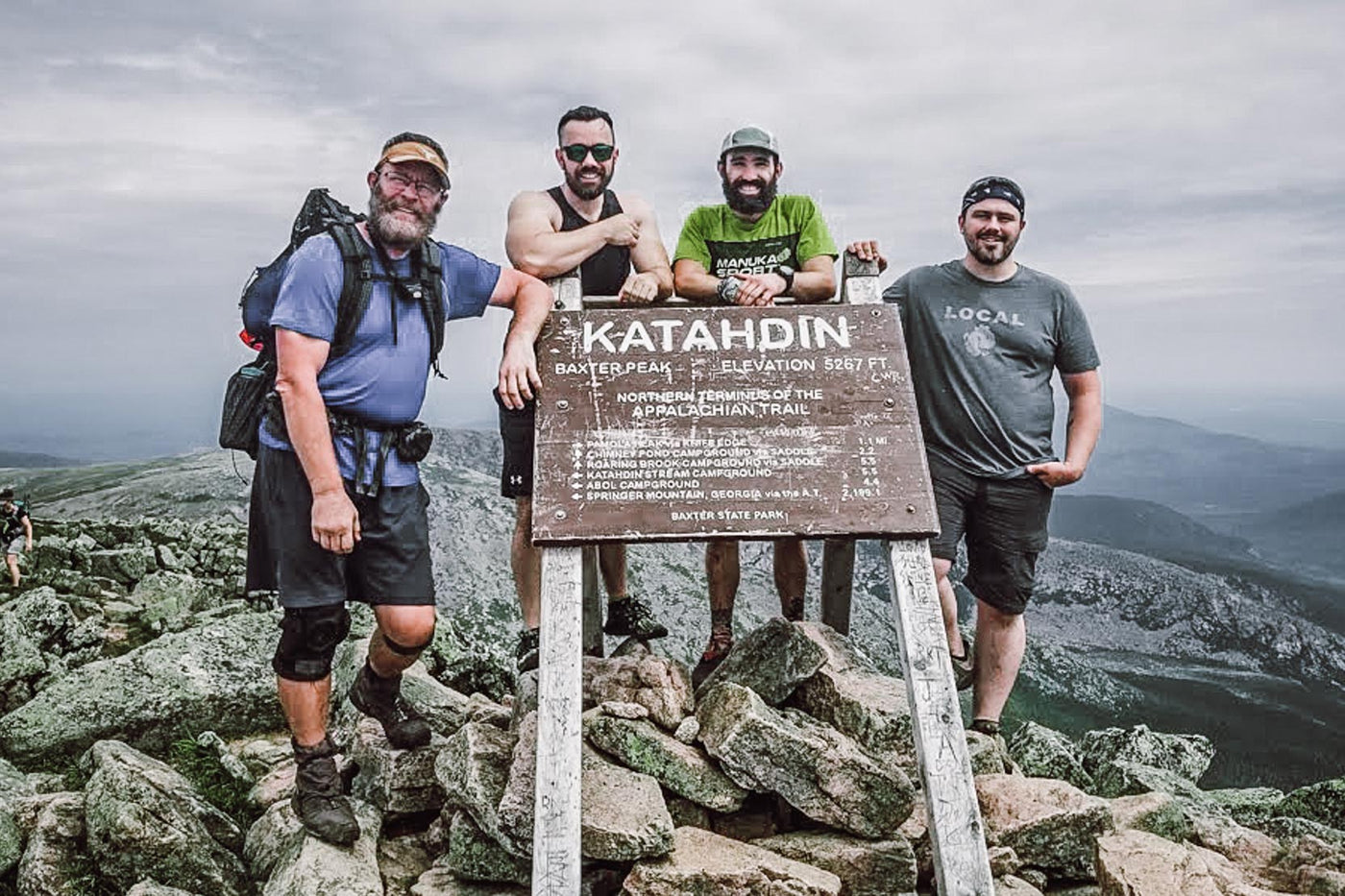
Once I entered the Hundred Mile Wilderness - the final and most remote stage before Katahdin - the countdown was really on. I took five full days to pass through, soaking up as much of the environment and scenery as I could. My brother and best friend were waiting for me at a campsite just before the final climb so that we could all do it together, and I was so thankful to have them supporting me and my trip. The morning after reaching them, we tackled the highest and most difficult mountain on the trail to put an end to my journey 98 days after beginning in Georgia.
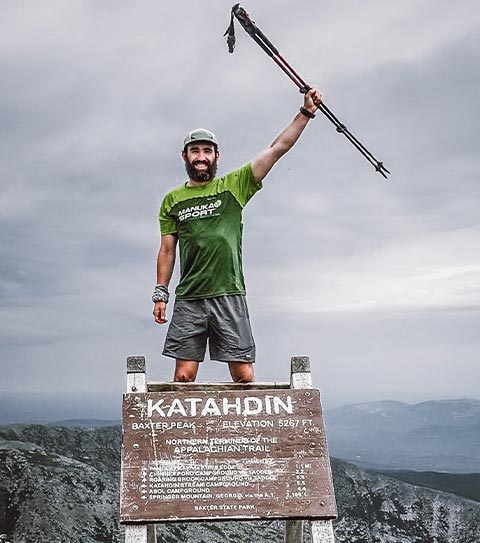 Finishing the AT!

Me, my brother, best friend, and another hiker at the Northern Terminus.
Thru-hiking the AT was a wonderfully powerful experience that challenged my mental fortitude, athletic capacity, and overall grit. It also motivated me to continue pursuing long distance hiking, fastpacking, and ultrarunning because I get so much satisfaction from the pursuit of endurance.To that end, I maintain my trail edge by regularly participating in ultramarathons, taking frequent trips to the woods, writing, and helping others plan and prepare for outdoor adventures as an instructor for Andrew Skurka’s Online Planning Course.
Though I was not aware of Path Projects until after completing my thru-hike, I can now conclude that they offer what I believe to be the ultimate pair of hiking shorts in the Graves PX. With pockets to store your phone for easy access to trail guides and podcasts, and others to stuff trash accumulated by snacking on the move, they are the ideal companion.
What’s more, by not having a liner to get in the way you have the ability to swap between thermal base layers when its cold and lightweight Torch liners when it’s swampy. Not only does this cut down on the amount of clothing you need to bring (which lowers you pack weight and increases comfort), but allows you to go longer between washes since you can rinse the liners independently. I wish I’d had these shorts during my thru-hike, but I’ve not worn anything else on the trail since discovering them!
More information about my thru-hike, gear, and other topics can be found on my blog, Fit For Miles. Happy Trails!
- Brandon Chase