A Trail Adventure in “The Old North State”
By: Path Projects customer Luke Stafford

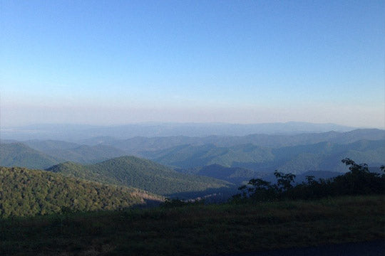
Have you ever run on a trail that climbs both the tallest mountain peak (Mt. Mitchell) and the highest sand dune in the Eastern United States? What about running on a trail that passes 3 light houses (including the nations tallest), connects 10 State Parks, passes through 4 National Parks and 2 National Wildlife Refuges? If you have not, North Carolina’s longest marked footpath, stretching from the Smokey Mountains to the Atlantic Ocean is calling your name! This beloved trail is called the Mountains to the Sea (MST) Trail and is my favorite trail on which to run. While the trail runs 1200 miles across the whole state, my most favorite part is Segment 3, which is called the “Mountain/Asheville Section.”


The “Mountains/Asheville Section” of the MST covers around 68 miles and includes sweet single track, challenging mountain climbs, and many rocks/roots that are typically seen on East Coast trails. The reward for all of this are sweeping, breathtaking views of the beautiful Blue Ridge Mountain Range. North Carolina has 4 distinct seasons and each one brings a new experience and enjoyment when running on the MST. Access to the “Asheville Section” of the MST is extremely easy because the MST runs parallel with the Blue Ridge Parkway, a major scenic highway. You can park anywhere right off the Parkway to access the trail. I have several favorite routes within this section which include: The Shut In Trail, The River to the Blue Ridge Parkway Visitors Center, and The Mount Mitchell Trail.

Favorite Trail Runs
The Shut in Trail Run
The Shut in Trail is a part of the MST Asheville Section that follows the old carriage path from the Biltmore House to George Vanderbilt’s Hunting Lodge on top of Mt. Pisgah. To access this trail, simply park at the NC Arboretum/French Broad River Access (off of HWY 191) and follow the trail, underneath a bridge and up to Mt. Pisgah. From the start, you will be constantly climbing up, usually on a single track path which is steep (3000 ft. gain total) and challenging (around 18 miles).

The Shut In Trail does cross the Blue Ridge Parkway several times, so if you have a crew or need to park a car halfway to store supplies, it is very possible. While your legs and lungs will be burning, you will be rewarded with beautiful Mountain views of Bent Creek Gap, Mills River Overlook, and Stoney Bald Overlook, just to name a few. This is a very popular route among Asheville trail runners and is a great fitness test for anyone training for a marathon or an ultra. Note, when estimating a finishing time for this run, use your average marathon finish time. For the last 40 years, Asheville locals have hosted a race on this trail which is in November and is challenging and well attended.
Google Maps Directions To Start of Shut In Ridge Trail.
The River to the Blue Ridge Parkway Visitor Center
This part of the MST runs through the heart of South Asheville, and is perfect for a morning run before work or for an evening run after the kids go to bed. Starting on the Blue Ridge Parkway just over the I-26 Bridge, there is a dirt area to pull off and park. Here, you can hop on the trail and start the 10-mile one way trip to the Parkway Visitors Center. The first five miles are marked by undulating terrain, rocks and roots and two road crossings.

There are plenty of pine trees to shade the summer sun and at mile 3 there is a big creek crossing which can also provide cool comfort. From the creek, you’ll begin your ascent through forest land and to the second crossing of the BR Parkway. Around mile 5, there is a MST trail marker which provides access to a side trail that can give you relief if you’re in need. What type of relief you might ask? If you need caffeine (Starbucks), gear (an outdoor store), or food (The Fresh Market) options exist ½ a mile away to ensure that you have what you need.
Miles 6-9 run below the Parkway and follow a circuitous route along the mountains. Highlights of this section are two stream crossings, running on a narrow tightrope trail section on the side of the mountain (mile 7), and beautiful single-track trail. Running Miles 9 to 10 is an enjoyable experience providing a couple of good views of East Asheville and ending up at the BR Parkway Visitors Center.
Google Maps Directions to the start of the trail.
Mt. Mitchell Trail

This part of the MST starts at the Black Mountain campground on the Toe River and climbs 3600 feet in 5 miles to Eastern United States highest point, Mt. Mitchell (6684 ft.). It is rugged, steep, and extremely rocky but there is great reward in the beautiful views. Leaving the campground, take a left at the campground loop road and follow the signs for the Mt. Mitchell trail. Almost immediately, the trail climbs up through dense forest, multiple switchbacks, eventually opening at Long Arm Ridge and continuing up to another opening, Higgins Bald.

Here you will be able to have stunning views of the Blue Ridge Mountains, while resting your quads. But, there is still more elevation to climb as the Buncombe Horse Range Trail merges with Mt. Mitchell trail for ½ a mile. Continuing past Commissary Hill and through lush moss and tall trees, you will eventually reach the summit of Mt. Mitchell and boy is it worth the work (Note that there are several water sources along the way). The stunning beauty of this run omits how hard you must work to attain the goal. It’s well worth the effort!


Google Maps Directions to Start
Local races in the Mountains the Sea
There are several great races in this area. Two popular ones are a November race on the Shut in Trail and Hell Bender 100 at Mt Mitchell Trail Race.
The Mountains to Sea Trail is a very beautiful, challenging trail which I thoroughly enjoy. Each segment holds different treasures and adventures for anyone looking for fun. During each run, I am constantly reminded how grateful I am to experience true beauty here in the Mountains of North Carolina. While the MST runs the whole state, my favorite part is Segment 3 “The Mountains/Asheville Section.” Hopefully I’ll see you out on the MST soon.
Side Note: As of this writing, please keep our friends in Eastern North Carolina in your thoughts with the flooding and destruction brought from Hurricane Florence.